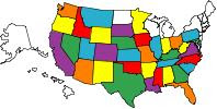
RV Travels - States Visited

RV Travels - States Visited

WELCOME

To view our blog, we have found it easier if you would click on the Archived Month located below the "About Us" article. There will be a list of posts with the oldest one at the bottom. Start with the oldest one and continue to click on each one to view the posts for that month. When you have viewed all the posts for that month then click on the next month.
Note: To view pictures, just click on them with your mouse. Hit the back arrow on your browser to return to blog.

We hope this will make it easier for you to navigate the blog and all the posts.
Enjoy the Blogspot and if you have questions concerning our travels, routes, areas of interests, campgrounds, etc., please email us at: sperrysrv@gmail.com
Showing posts with label Utah. Show all posts

Monday, July 13, 2009

Zion National Park to Barstow, California

Friday - July 9th
We left Zion NP on UT9 which led us to Interstate 15. This will take us the 300 miles to Barstow, California. We need to be there before 9pm PST so we can get into the KOA campground at Calico Ghost Town. Our travels took us thru the Mohave desert in California. We didn't see a California Welcome Center until we were getting close to Barstow. Naturally, being on a time schedule, we just blew by it.

We arrived at the KOA at 850 and got a campsite for two nights. Temperature was 97 degrees when we got the MH set up for the night.

The pictures below covers the trip from Zion to the campground. Please enjoy!


Arizona Landscape. Sharon tried to take a picture of the "Welcome to Arizona" sign but we were cruising pretty good when the sign appeared.


Notice the landscape - color is solid "sandstone". Nothing else!


Skyline of Las Vegas.


Traffic at 7pm going thru Vegas. What was it like at rush hour??


Trump Tower!


Casino Bellagio flys by as we fight the traffic at 60 mph.


Nice! Casino, New York New York enhances the skyline.


Reflections of the late evening sun on Mandalay Bay.


Welcome to California. It looks like the rest of the desert country.


We will be leaving here on the 11th after a visit to Calico Ghost Town. Our next stop will be Sequoia National Park. Stay tuned, this could be interesting!
Happy Trails!

Glendale KOA to Zion National Park

Thurs - July 9th
We spent the night in Glendale, Utah at a KOA campground. After visiting 2 National Parks yesterday we didn't spend much time looking for a campground. This one was near the highway and convenient.

This morning we woke up to 40 degrees. We went to bed with the AC running and I turn the heat pump on when I woke up this morning. It will be 40 degrees higher in 2 hours and will be in the 100s this afternoon. Getting used to it is a hard thing to do.

We are traveling from Bryce Canyon on UT12 and then south on US89 to UT9 which will takes us to Zion NP. This will let us enter the park from the northeast. The Visitor Center is on the southwest side.

When we entered the Park they informed us that there was a charge for an escort to get us thru the tunnel in Mt. Carmel. It is one mile long and only 13.1' high in the center. The tunnel was finished in 1930 and the top is oval shaped topping out at 13.1'. Our MH is over 12' and is not oval. We are concerned because it is many miles, if we have to go around, to get to the other side. We paid the $15. for the escort who were Park Rangers, one on each side of the tunnel. They stopped the traffic so we could go thru the tunnel down the center line of the 2 lane road.
I never heard anything hit the top but was really worried about it.

When we arrrived at the Visitors Center, parking was very limited, due to many visitors already there. We parked in the car & truck parking area since everything was full and they gladly gave me a warning ticket for doing this.

We opted for the tour bus so we could get to best places without driving the MH. This is the best way to tour Zion NP. We really enjoyed it. Zion NP elevations range from 3600 to 8700' and provide vastly different environments. Fir, aspen, & pine flourish in the high country while pinon, cliffrose and mesquite love the desert heat. This is a beautiful park but not a pristine park. Adding the free tour bus service gets a lot of visitors to places that they normally couldn't see. They do a wonderful job of moving the people from place to place at your leisure. The Virgin River runs thru this area and continues on to the southwest.

Enjoy the pictures below!


Check out the new hat. We both got one. Race car drivers wear helmets to protect their heads. Cowboys wear them to protect their head and neck. After getting sun burned on the ears, nose, and neck we decided to invest in head protection. They worked well.


Check out the rock formation. It is a checkered board pattern.


I couldn't resist taking a picture of the MH with the big rocks in the background.


Sharon enjoying the view. We both are in awe with the outstanding works of Mother Nature.


If you look at the center of the picture you will see one of the side openings to the tunnel. We believe this is for ventilation. Looking at the size of the mountain, I can't believe we drove 1 mile thru this thing.


Here's a closeup of the 2nd opening in the side of the tunnel.


Here's a closeup of the 1st opening in the tunnel.


This is a view of the terrain after we left the tunnel.


Looking down, you can see the road we will be traveling, to get down off Mt. Carmel.


Whew!! we are at the bottom of the mountain.


This is a picture of the Patriarchs. Abraham, Isaac, & Jacob.
Most of the rock formations have religious names compliments of the Mormons.


Tour bus in background


Bus stop with a view.


Here's the tour bus coming into Zion Lodge area.


Weeping rock is where the springs are continually dripping.


Sharon saw this sign and said "Let's go back!"


Instead, we took a different trail. We are glad we did! Look at the deer that was on the trail that we would have missed going the other way.


Sharon and other tourists enjoying the cool damp air under the weeping rock in Echo Canyon.


Weepin Rock water runs down the hill along with other drains forming the creek below the bridge. Several people had pulled off their shoes and were enjoying the water.


This rock formation is known as "The temple of Sinawava"


Over 100 degrees, Sharon is thinking about wading in the Virgin River. I encouraged her to get in the water.


Ther she goes. I guess I will take her shoes to her when she gets cooled down.


This is a park well worth visiting. Park your vehicle at the Visitor Center or a nearby town. Get on the tour bus and enjoy what Mother Nature has provided. We did and we are glad we did!

As we leave here we will be traveling thru the very nothwest corner of Arizona on Interstate 15. It will takes us thru downtown Las Vegas and into California.

Enjoy the pictures and until the next update......Happy Trails!

Bryce Canyon National Park

Wed - Jul 8th
We left Capital Reef on UT12. This is a beautiful scenic highway. The elevation continues to climb up to 9600 feet. The vegetation also changes with the elevation.

The worse part was trying to drive our MH on a 22' two lane road that follow the crest of the mountain range. The road bed wasn't 35' wide with massive cliffs on both side. The MH felt like it was too big to even be on this road. The elevation climbed from 8860 to 9600' as I drove about 15mph.

Anyhow, sometimes (I said sometimes) getting there is most of the fun. We made it as you can tell, otherwise you wouldn't be reading this update.

We decided that we would go to campground and go to bed after this day was over.
We did just that, too!!

Enjoy the pictures....................


On the way to Bryce Canyon NP we passed many Ponderosa Pines.


As we climbed higher we notice more & more Aspens were filling the landscape.


This is the road on top of the mountain crest I described earlier. Check out the side of the payment. Road is broken off and fell down the mountain, no guard rails.........What are we doing here????


Sharon snapped a lot of pictures showing the side of the road and how far down you can see. I think this covered up the fear she was feeling.


We finally arrived at the Visitor Center. We took UT63 south from UT12 to get here. After a short visit and some shopping we climbed aboard the MH to take in the rest of the sights. I found out later that they have a free shuttle to take you in the canyon. That would have been nice!


Here is a view of one of the canyons.


The view is never ending!


At this overlook they had a sidewalk that went a quarter mile down the side of the canyon wall. On the right side of the picture you can see where it starts.


Each view is breathtaking! America the beautiful - no doubt!


This is really an arch but was mistakenly named "Natural Bridge". Bet they wish they could take that name back so they could have an arch in their Park.


Okay, I have to get in the pictures once in a while. Sharon keeps insisting so what can I do?


Ponderosa Point - Elevation 8904


Rainbow Point - Elevation 9115


We are traveling to Sandstone this evening to get a campsite at a KOA campground. After a couple of shots of something, we may be relaxed enough to go to sleep.

Tomorrow we will reach our final destination in Utah and that is Zion National Park. Naturally we will be enter the park from the wrong side so this one will be fun, too.

Until then - sleep tight and Happy Trails.................................

Friday, July 10, 2009

Durango, Co. to Arches NP & Hanksville, Utah

Mon - July 6th

It was a nice 69 degrees when we left the campground in Cortez, Colorado and turned northwest. Destination - Arches National Park, Utah.

We traveled on US491 with the mountains behind us. Most of the terrain was flat, farmed, and covered with Alfalfa. Numerous very large ditches were cut around the farms for either drainage or irrigation.

We enjoyed the peaceful drive along the country highways.
Once we crossed the state line into Utah it didn't take long before we started seeing the mountains again.


We turned north on US191 and started to see what looked like solid rocks for mountains. They continued with many different shapes and colors.


We arrived at the Arches National Park after a 2 1/2 hour drive. It was already in the upper 90s and the sun was HOT!!!!
Arches are formed by water & ice, extreme temperatures, & underground salt movement. They range in size from a 3' opening (the minimum) to 360' base to base like the Landscape Arch. (the most popular arch) As time goes on new arches are formed and old ones change or disappear with the effects of weathering and erosion.
More than 20 motion pictures have been filmed here and not all of them were westerns.


The road to the Arches zig-zags up the mountain behind the motorhome.

Also the walking trails will do the same to get to the viewing areas of the Arches.


A view back down to the parking lot shows the twisting road that we used to get up the mountain. Little did we know what was in store for us later.


Here is an outstanding view of the terrain.


Sharon, with the view of "Balanced Rock" behind her. This trail was only .3 of a mile


Native Plants - Juniper. they have a strong pungent odor about them. The roots grow very long digging into cracks in the rocks for water. The tree will cut off water to some limbs, letting them die, to preserve the rest of the tree.


Look hard and you will see me and quite a few others in the north Window Arch. It was very shady underneath with a strong wind. That made it worth while to hike to this Arch.


Here's a view back to the parking lot. The trail to the north Window Arch is 3/4ths of a mile.


We continued on the trail until we could see both the north & south Window Arches.


The most photographed arch is the Landscape Arch. We drove to the parking area near here, got our water bottles, hats, and determination in check then hit the trail. It was 102 degrees in the shade and we were looking at over 1 1/2 miles of up & down terrain, sanding trails, & very little shade to get there.

Sharon at our 2nd break in the hike.


Finding some shade to cool down under was limited on this hike.

The prairie is beautiful and fitting for any postcard.


Most of the time you're looking up and will miss some of the flowers and desert creatures that live here. Here's a picture of a Spotted Lizard. I tried to find out the name but all I can find is Spotted Lizard. Guess that will have to do.


Whew! What a hike! We finally made it and believe me, it was worth it. This fragile arch may not be here for our grandchildren to see.


Red face, hot, and sweating we asked another red faced person to take some pictures of us and he took about 5 of them. We thank him and took a couple of pictures of his group before we left.

Even though we were tired, hot, sweaty, & winded we managed to keep our tempers in check and enjoy what we came here for.

We left Arches NP & continued north on US191 towards I70. We stayed on the interstate for about 30 miles. We then took Utah 24 south to Hanksville, Utah. We were both pretty tired from the miles and the heat, so we nailed a campground in the desert.


Here's a view of the campground. We were surprised by the sand spurs that were in the gravel all over the campground. These little guys hook to your shoes and end up in the motorhome. Trust me, they don't feel very good when you are barefoot. It only took one lesson to get us to police the carpet in the MH and check our shoes from now on.


When Sharon was directing me into the campsite she heard this loud noise behind her. Cattle climbing on piles of pipes to get to a bush by the fence. They must have been pretty hungry.


Check our the horns on this baby. That would make anyone a fine hat rack or a hood ornament for their truck. (haha)


I couldn't pass this one up either. Another junk pile directly behind the campsite. I guess we are spoiled.
We have noticed that out here most people collect their own junk.
The more they have may say something for their status in the neighborhood. It doesn't represent their net worth but what they have spent, used, and discarded.
Arizona, New Mexico, & Utah will have an enormous supply of metal if we ever need it.


We stayed here a couple of days, no cell, & no Wi-Fi - just rest and relaxation. When we leave here we will travel to Capital Reef NP & then to Bryce Canyon NP.
Hopefully, not too many more trails but if necessary, we will tackle them too.

Stay tuned and Happy Trails.